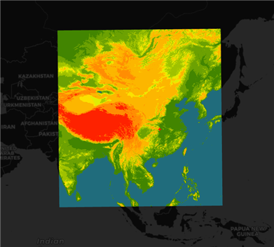
1. 在地图上添加一个GeoTIFF的图片。
2. 主要使用了 GeoTIFF 和 GeoTiffPlane 对象。
3. 加载完成后为image图片,并使用material进行渲染。
 1  fetch(‘https://gw.alipayobjects.com/os/rmsportal/XKgkjjGaAzRyKupCBiYW.dat‘).then(res => res.arrayBuffer()).then(arrayBuffer => {
 2                 GeoTIFF.fromArrayBuffer(arrayBuffer).then(tiff => {
 3                     return tiff.getImage();
 4                 }).then(image => {
 5                     const width = image.getWidth();
 6                     const height = image.getHeight();
 7                     image.readRasters({}).then(data => {
 8                         const time = ‘time‘;
 9                         console.time(time);
10                         const plane = new GeoTiffPlane([73.482190241, 9.62501784112, 134.906618732, 60.4300459963], {
11                             imageWidth: width,
12                             imageHeight: height,
13                             imageData: data[0]
14                         }, material, threeLayer);
15                         console.timeEnd(time);
16                         threeLayer.addMesh(plane);
17                         lines.push(plane);
18                     })
19                 })
20                 // const image = tiff.getImage();
21                 // const width = image.getWidth();
22                 // const height = image.getHeight();
23                 // const values = image.readRasters();
24             })
4. 页面显示
5. 源码地址
https://github.com/WhatGIS/maptalkMap/tree/main/threelayer/demo
maptalks 开发GIS地图(33)maptalks.three.26- custom-geotiffplan
原文:https://www.cnblogs.com/googlegis/p/14736002.html